The results support frozen geospatial embeddings as a low-compute candidate for regional cropland mapping, subject to the limits of a single-state study, a 30 m-derived training reference, and a one-block human validation.
Abstract
Geospatial foundation models provide reusable representations of satellite imagery that support downstream mapping with limited task-specific modelling. We evaluate whether annual AlphaEarth embeddings support binary cultivated-versus-non-cultivated mapping in Maine, USA, using 192 spatially separated patches and labels derived from the USDA Cropland Data Layer (CDL). Without fine-tuning the foundation model, a lightweight classifier reaches 93.7% overall accuracy and 90.8% balanced accuracy on held-out patches. Logistic regression is within 0.3 percentage points of a gradient-boosted ensemble, while a nearest-class-centroid rule, which uses class centroids but fits no parameters, reaches 90.2%. A balanced sample of 60,000 labelled pixels is within 1.3 percentage points of the full pool of 8.6 million pixels; because pixels are spatially autocorrelated, this result concerns pixel-sample efficiency rather than 60,000 independent annotation sites. In a same-region transfer experiment, classifiers trained in one year remain accurate across 2018 to 2023. Against a blind, two-interpreter consensus at 385 randomly sampled points in one contiguous 2023 block, the AlphaEarth-plus-random-forest map agrees at 95.3% ($\kappa=0.82$), compared with 91.7% for the CDL ($\kappa=0.72$; exact two-sided McNemar $p=0.0161$). This local result is consistent with partial smoothing of CDL label noise, but it does not establish statewide correction of the reference product. On the same points, the difference from a fine-tuned TerraMind segmentation model is not statistically significant (95.3% versus 93.5%; $p=0.14$), and the experiment is not a controlled comparison of computational cost. These results support frozen geospatial embeddings as a low-compute candidate for regional cropland mapping, subject to the limits of a single-state study, a 30 m-derived training reference, and a one-block human validation.
TESSERA latent embeddings are a well-suitable input to fraction mapping, performing slightly better than spectral-temporal-metrics-based models in many cases, but spline coefficients generally perform best when sufficient high-quality observations are available.
Franz Schug, David Klehr, Jari Mahler et al.· 0 citations
Ecosystems and the services they provide are essential for life but continue to undergo degradation worldwide. Satellite remote sensing has been essential for environmental mapping for decades, but can suffer poor accuracy when applied to mapping terrestrial ecosystems. Geospatial Foundation Models (GeoFMs) integrate d...
George W. Lucas, Benjamin J. Cresswell, S. Duce et al.· Remote Sensing· 0 citations
The resulting map, released as an open-access product, is the first high-resolution national tree species map of Denmark and provides a valuable resource for forest monitoring, ecological research, and land management applications.
Alkiviadis Koukos, Spyros Kondylatos, T. Nord-Larsen et al.· 0 citations
Accurate forest-cover mapping is essential for large-scale resource monitoring; however, acquiring dense pixel-level labels remains costly and limits practical scalability. This study investigates the use of publicly available land-use/land-cover products (PLCPs) as supervisory signals to alleviate the scarcity of high...
Qianhuizi Guo, Ling Han, Qiu-Chang Xie et al.· IEEE Journal of Selected Top...· 0 citations
Frozen geospatial foundation model (GeoFM) embeddings are increasingly used as general-purpose features, yet their reliability under cross-city transfer remains unclear. We evaluate AlphaEarth and TESSERA for building-function and local-climate-zone mapping across 31 cities using leave-one-city-out (LOCO) transfer, com...
Jungoung Kim, Hunsoo Song· IEEE Geoscience and Remote S...· 0 citations
Exploring how generative AI could make machine vision more accessible to businesses. The post GenEye in a Box: Making Machine Vision Something You Can Just Ask For appeared first on GPT-Lab.
Microsoft Research Blog· microsoft.comAug 11, 2026
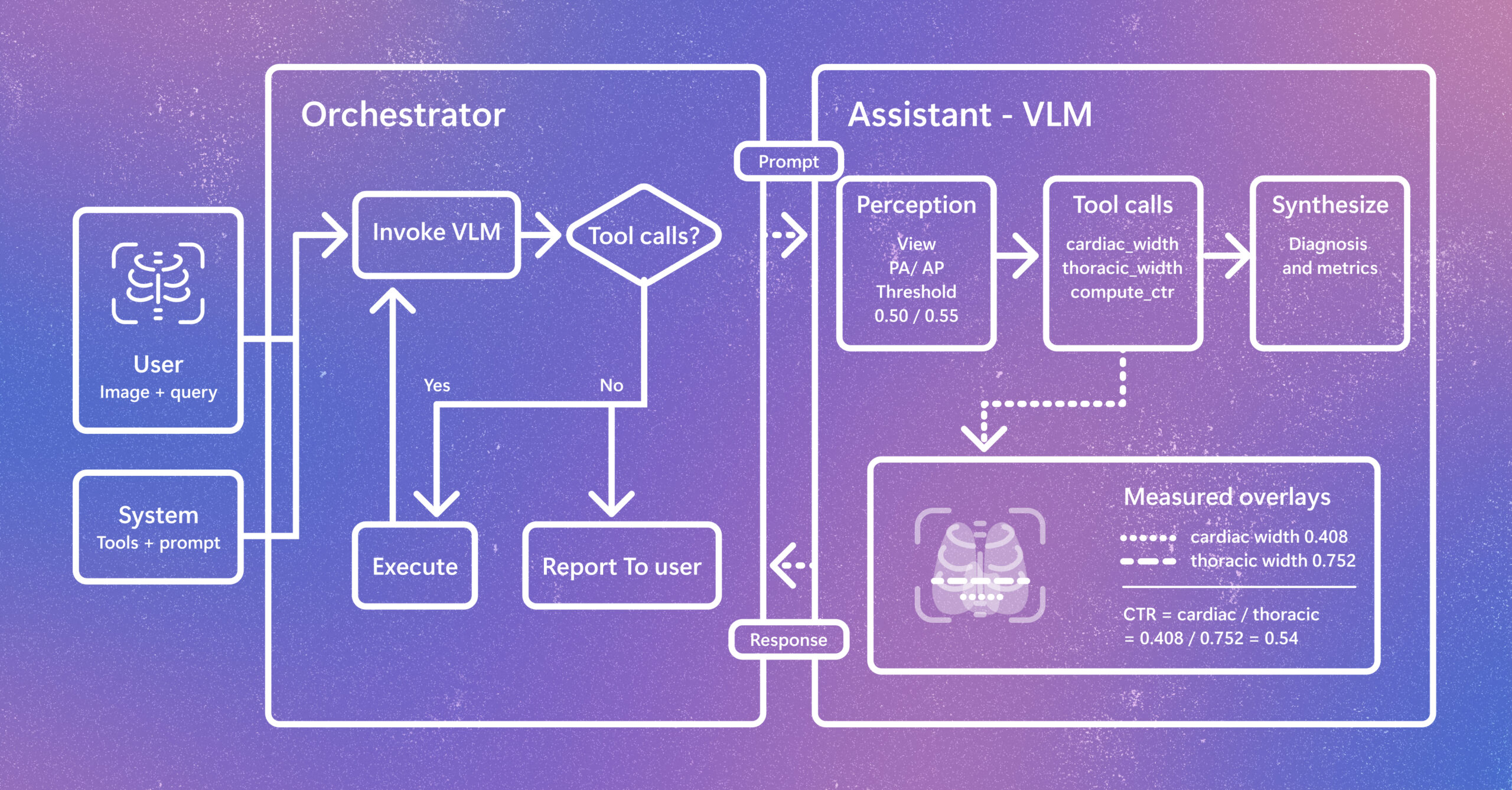
Radiology AI is evolving beyond report generation. CARE-X explores a unified approach that combines flexible reasoning, calibrated predictions, and measurement-based tools for chest X-ray interpretation. The post Introducing CARE-X: Towards Clinically Useful Radiology VLMs with Auxiliary Supervision, Reward-Aligned Learning, and Tool-Augmented Measurement appeared first on Microsoft Research.
StudentSim is a research system for evaluating and improving AI tutoring tools before they are tested with learners. It models how individuals may engage with tutors, giving feedback to improve tutor performance across subjects like chess, writing, and mathematics. The post Simulating student learning for better AI tutoring appeared first on Microsoft Research.
We use cookies to run the site and, with your consent, for analytics and to show ads.
See our Cookie Policy.