The value of reusable coefficient fields for accurate reconstruction beyond the supervised resolution with low incremental arithmetic cost is demonstrated and SCOPE leads the compared methods across six metrics in the main supervised-scale evaluation.
Abstract
High-resolution digital elevation models (DEMs) support Earth observation applications, but paired training references are often available only at coarser output resolutions. Reconstructing finer terrain grids therefore requires both effective transfer beyond the supervised scale and control of dense-query computation. To address this problem, SCOPE learns a continuous terrain representation from coarser-resolution pairs. It predicts a latent coefficient field on the low-resolution grid and reuses local Fourier residual functions through basis evaluation and geometry-guided ensemble fusion. This separates high-dimensional coefficient prediction from output-grid construction. Experiments on geographically distributed land--ocean samples assess supervised reconstruction, unseen-scale inference, cross-domain generalization, and theoretical computation. SCOPE leads the compared methods across six metrics in the main supervised-scale evaluation. At an unseen factor three times the training factor, land reconstruction reduces RMSE and MAE by approximately 12\% relative to bicubic interpolation, with errors close to target-scale fine-tuning. Ninefold output density increases counted multiply--accumulate operations by only about 2\%. Frozen-model validation on held-out external marine regions reduces RMSE relative to the DEM-specific implicit baseline EBCF-CDEM by approximately 19\% under self-downsampling and 2\% with cross-product inputs, while also yielding lower RMSE than LIIF-MS in both settings. These results demonstrate the value of reusable coefficient fields for accurate reconstruction beyond the supervised resolution with low incremental arithmetic cost.
Spatial downscaling of satellite imagery, the reconstruction of high-resolution outputs from coarser-resolution inputs, is a critical enabler of long-term land cover monitoring, yet the domain adaptation gap between natural-image super-resolution models and satellite sensor characteristics remains largely unaddressed....
Juan Valdés-Quintero, R. D. Vásquez-Salazar, J. C. Parra et al.· Italian National Conference...· 0 citations
Satellite image super-resolution (SR) is a critical task in machine vision, supporting applications such as urban planning, agricultural monitoring, and disaster response. The objective of SR is to enhance the spatial resolution of low-resolution (LR) satellite imagery, thereby extracting finer detail. Over the past...
V. Kniaz, Petr V. Moshkantsev, V. Aleksandrov et al.· The International Archives o...· 0 citations
Terraced fields are difficult to delineate from high-resolution imagery because narrow and irregular boundaries, fragmented patches, and visual similarity to adjacent cropland can lead to omission errors and boundary confusion. This study adapts DeepLabV3+ for terraced field extraction from 2 m GF-1 RGB imagery through...
Jia-Lin Li, Jie-Lin Tang, Bo Jia et al.· Remote Sensing· 0 citations
Experiments show that DGSRef improves diverse segmentation architectures with limited additional computation and parameters, confirming its effectiveness as a lightweight decoupled refinement framework.
Abstract. Bare-earth Digital Terrain Models (DTMs) are fundamental to geospatial applications, yet publicly accessible global elevation products are Digital Surface Models (DSMs) with vertical accuracies of 4–15 m RMSE at 30 m or coarser resolution. Airborne LiDAR achieves sub-metre accuracy but remains costly and spat...
Xiandong Cai, Matthew D. Wilson· The International Archives o...· 0 citations
High-resolution digital surface models (DSMs) play an important role in urban analysis, 3D building reconstruction, and infrastructure monitoring, yet their availability remains limited due to the high cost and complexity of data acquisition. In contrast, coarse DSMs from commercial satellite missions are widely access...
A. Nicolicioiu, Dominik Narnhofer, Nando Metzger et al.· 0 citations
Exploring how generative AI could make machine vision more accessible to businesses. The post GenEye in a Box: Making Machine Vision Something You Can Just Ask For appeared first on GPT-Lab.
Microsoft Research Blog· microsoft.comAug 11, 2026
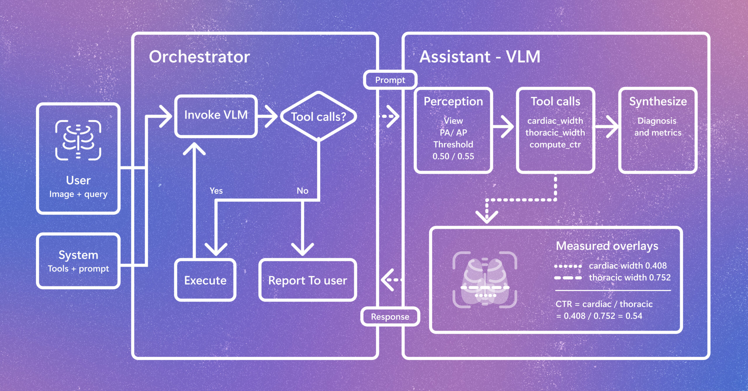
Radiology AI is evolving beyond report generation. CARE-X explores a unified approach that combines flexible reasoning, calibrated predictions, and measurement-based tools for chest X-ray interpretation. The post Introducing CARE-X: Towards Clinically Useful Radiology VLMs with Auxiliary Supervision, Reward-Aligned Learning, and Tool-Augmented Measurement appeared first on Microsoft Research.
Students in MIT’s Concourse program delve deeply into the human condition, debate challenging questions, and learn to develop judgment about issues that can’t be quantified.
We use cookies to run the site and, with your consent, for analytics and to show ads.
See our Cookie Policy.